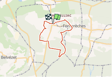
Les Lavoirs autour de la Bruguière

JMJ42
User

Length
12.3 km

Max alt
290 m

Uphill gradient
166 m
Km-Effort
14.5 km

Min alt
233 m

Downhill gradient
168 m
Boucle
Yes
Creation date :
2024-02-26 17:23:53.043
Updated on :
2024-02-26 17:24:32.932
3h18
Difficulty : Difficult

FREE GPS app for hiking
 SityTrail
IGN / Geographical institutes
SityTrail Plus
The world is yours!
About
Trail Walking of 12.3 km to be discovered at Occitania, Gard, La Bruguière. This trail is proposed by JMJ42.
Positioning
Country:
France
Region :
Occitania
Department/Province :
Gard
Municipality :
La Bruguière
Location:
Unknown
Start:(Dec)
Start:(UTM)
613187 ; 4885177 (31T) N.
Comments